File:Earthlights dmsp.jpg
Composite image of the Earth's night surface (2000). This image is not a photograph and details appear brighter than they really are.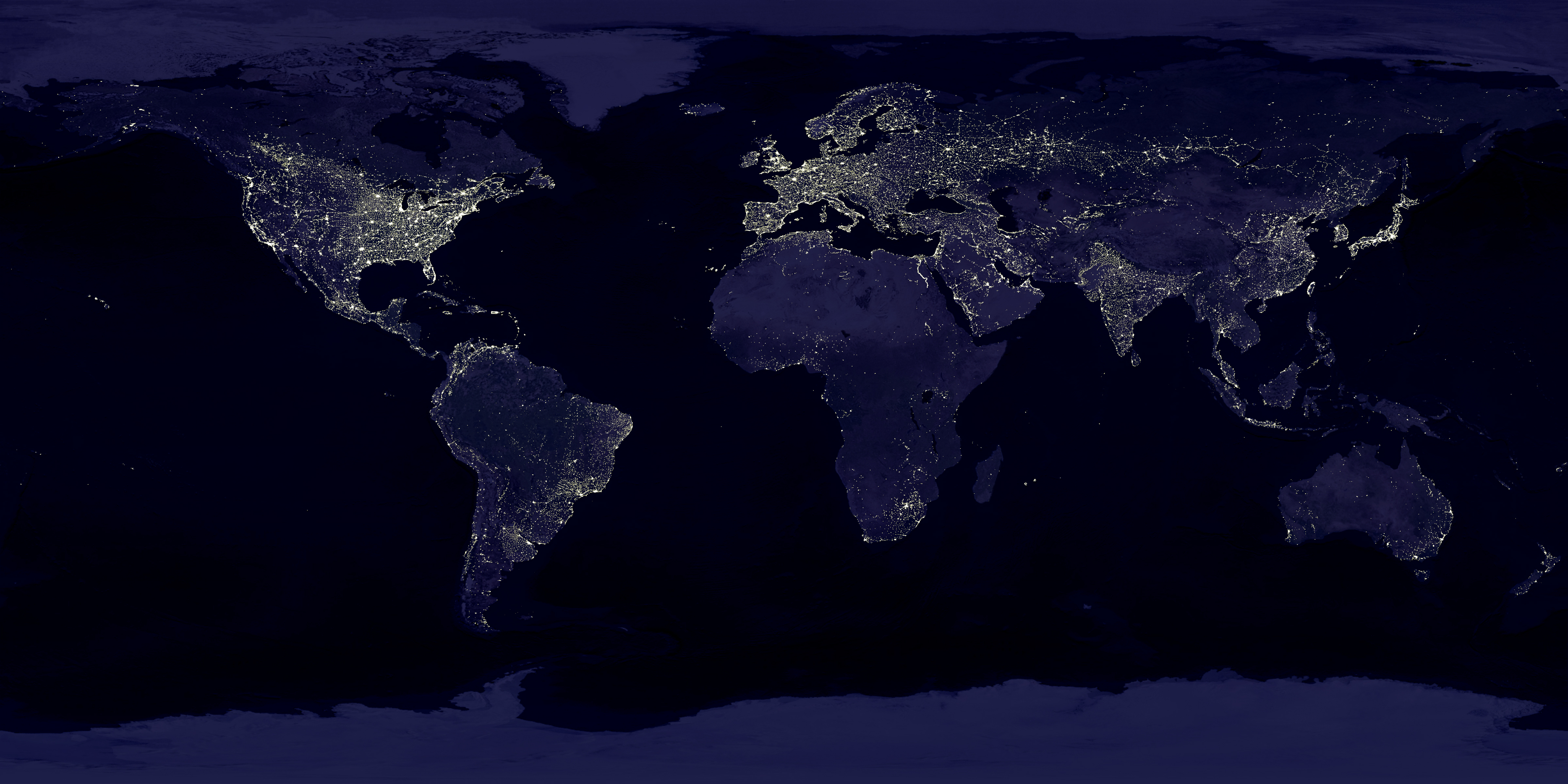
Original file (4,800 × 2,400 pixels, file size: 4.03 MB, MIME type: image/jpeg)
Captions
Captions
|
This image was selected as picture of the day on Mediatop for . It was captioned as follows: English: Composite image of the Earth at night Alemannisch : Zommegsetzts Bild vun de Erd bie Nacht Čeština : Složený satelitní snímek Země v noci Deutsch: Die Erde bei Nacht (zusammengesetztes Bild) English: Composite image of the Earth at night Español : Imagen compuesta de la Tierra de noche Français : Image composée de la terre la nuit. Galego : A Terra de noite Íslenska: Jörðin í myrkrinu (samsett mynd) Italiano : Immagine composta della Terra di notte. Lëtzebuergesch: D'Äerd bei Nuecht. Magyar : Kompozíció a Föld éjszakai felvételeiből Norsk bokmål: Sammensatt bilde av jorden om natten. Norsk nynorsk: Samansett bilete av jorda om natta. Polski: Mozaika zdjęć satelitarnych Ziemi wykonanych w nocy. Português : Imagem composta de Terra à noite Suomi: Mosaiikkikuva öisestä maapallosta. Български : Съставно изображение на Земята нощем Русский : Земля ночью (составное изображение) Српски / srpski : Састављена слика Земље ноћу 日本語: 夜の 地球 の合成写真 中文: 地球 夜景合成照片 |
Summary
| Description |
العربية: صُورة مُركَّبة لِلأرض ليلًا.
Français : Image composite de la Terre la nuit.
English: This image of Earth’s city lights was created with data from the Defense Meteorological Satellite Program (DMSP) Operational Linescan System (OLS). Originally designed to view clouds by moonlight, the OLS is also used to map the locations of permanent lights on the Earth’s surface.
The brightest areas of the Earth are the most urbanized, but not necessarily the most populated. (Compare western Europe with China and India.) Cities tend to grow along coastlines and transportation networks. Even without the underlying map, the outlines of many continents would still be visible. The United States interstate highway system appears as a lattice connecting the brighter dots of city centers. In Russia, the Trans-Siberian railroad is a thin line stretching from Moscow through the center of Asia to Vladivostok. The Nile River, from the Aswan Dam to the Mediterranean Sea, is another bright thread through an otherwise dark region. Even more than 100 years after the invention of the electric light, some regions remain thinly populated and unlit. Antarctica is entirely dark. The interior jungles of Africa and South America are mostly dark, but lights are beginning to appear there. Deserts in Africa, Arabia, Australia, Mongolia, and the United States are poorly lit as well (except along the coast), along with the boreal forests of Canada and Russia, and the great mountains of the Himalaya. |
| Date | between 1 October 1994 and 31 March 1995 |
| Source | https://visibleearth.nasa.gov/view.php?id=55167 (image link) |
| Author | Data: Marc Imhoff/NASA GSFC, Christopher Elvidge/NOAA NGDC; Image: Craig Mayhew and Robert Simmon/NASA GSFC |
| Other versions |
|
.jpg)
.jpg)
.png)

| 360° | View in 360° panoramic viewer
|
|---|
.jpg)
Licensing
| This file is in the public domain in the United States because it was solely created by NASA. NASA copyright policy states that "NASA material is not protected by copyright unless noted". (See Template:PD-USGov, NASA copyright policy page or JPL Image Use Policy.) | ||
 |
Warnings:
|
File history
Click on a date/time to view the file as it appeared at that time.
| Date/Time | Thumbnail | Dimensions | User | Comment | |
|---|---|---|---|---|---|
| current | 18:45, 2 April 2014 |  | 4,800 × 2,400 (4.03 MB) | Tholme (talk | contribs) | Higher quality version saved from original tif. |
| revert | 02:28, 12 January 2013 |  | 16,384 × 8,192 (8.11 MB) | Twinsday (talk | contribs) | Reverted to version as of 23:16, 24 October 2005, orginal contrast is more realistic |
| revert | 17:26, 23 August 2012 |  | 16,384 × 8,192 (13.5 MB) | Kintetsubuffalo (talk | contribs) | Reverted to version as of 21:22, 6 March 2012 explanation? |
| revert | 08:11, 23 August 2012 |  | 16,384 × 8,192 (8.11 MB) | Twinsday (talk | contribs) | Reverted to version as of 23:16, 24 October 2005 |
| revert | 21:22, 6 March 2012 |  | 16,384 × 8,192 (13.5 MB) | Soerfm (talk | contribs) | Brightness |
| revert | 23:16, 24 October 2005 |  | 16,384 × 8,192 (8.11 MB) | Bricktop (talk | contribs) | full res |
| revert | 11:38, 21 July 2005 |  | 2,400 × 1,200 (534 KB) | Nk (talk | contribs) | ''Composite image of the Earth at night, created by NASA and NOAA.'' '''NASA Description''': This image of Earth’s city lights was created with data from the Defense Meteorological Satellite Program (DMSP) Operational Linescan System (OLS). |
.jpg&action=revert&oldimage=20140402184555%21Earth%27s_City_Lights_by_DMSP%2C_1994-1995_%28large%29.jpg)
.jpg&action=revert&oldimage=20130112022814%21Earth%27s_City_Lights_by_DMSP%2C_1994-1995_%28large%29.jpg)
.jpg&action=revert&oldimage=20120823172632%21Earth%27s_City_Lights_by_DMSP%2C_1994-1995_%28large%29.jpg)
.jpg&action=revert&oldimage=20120823081142%21Earth%27s_City_Lights_by_DMSP%2C_1994-1995_%28large%29.jpg)
.jpg&action=revert&oldimage=20120306212212%21Earth%27s_City_Lights_by_DMSP%2C_1994-1995_%28large%29.jpg)
.jpg&action=revert&oldimage=20051024231604%21Earth%27s_City_Lights_by_DMSP%2C_1994-1995_%28large%29.jpg)
File usage on FKAWP uneditable projects
The following 1 pages use this file:
File usage on other wikis
The following other wikis use this file:
-
0 pages use this file.
Metadata
© GEL'S Special.